The main actors who decide how the city is built does not care about popular and laborers sectors. The State, whether national, provincial or municipal, large construction companies or real estate companies they build based on profits or to “revalue” urban spaces and not for the great needs of the majorities. What happened and is happening in Bahía Blanca from flooding and flooding is a great sample of this contempt for workers and the people in the capitalist urbanization process.
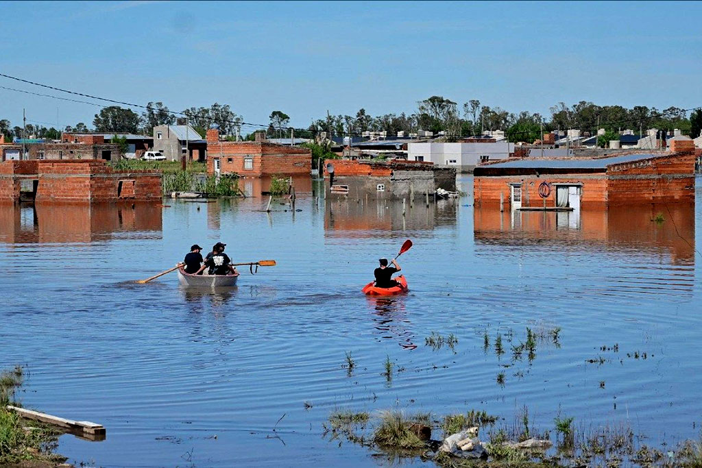
The city is located in the lower basin of the Napastá Grande stream, which crosses the city in the north-south direction and that, before intense rainfall in short periods of time in the middle or upper basin near the window hill, causes the stream to “fall” with a lot of flow and floods the bottom where Bahia is located, as happened on March 7. This level of rainfall, based on climate change, will not be as exceptional, as we explain here, here, here, but each time they will develop this recurrent. The theme is: Does it affect everyone equally? Definitely not.
Precarious settlements, misery villas, occupy less valued urban spaces, land that practically have no value in many cases. And this happens for different reasons: because they are very contaminated and building a little house there implies giving up health not only one, but of the whole family, child, grandparents, friends, etc. This is the case of the town of Engineer White, which is located not only next to the port but of one of the largest petrochemical poles in the country. Locations like this, in addition to being very exposed to pollution, are flood land, lands that are typical of the Napastá stream and when it grows it occupies those spaces with its great flow. This is not something unknown to governments. They know it a long time and they don’t care since there are scientific reports like this one that alert it a long time ago.
Barrios such as Villa Delfina, Loma Paraguaya, Enrique Julio, Maldonado, Vista Alegre II, doors of the South, Martín Fierro, Villa Bordu, Ing White, Thompson, Punta Blanca, Postal del Este, or the precarious neighborhoods of the town of Gral. Cerri, among many others that we can name from the area, have a great precariousness, above all things, for the great exposure to the floods and constantly suffer this type of events that the floods constant Governments and companies that build the city do not care in the least. They do nothing about it.
Clear example is the recent visit from Kicillof to Bay exactly one month before disasteron February 7, to inaugurate the infrastructure work that had the most financial support from the province in recent times in the city: the North Circunvalación highway, for a value of more than 9 billion pesos, a highway that connects to the north of the city, where private neighborhoods such as Alto Forest, La Reserve, Norte’s Solar among others are located. Exactly in the opposite pole, to the south, there are most popular neighborhoods named, which do not receive a room of that financial support. Why are private neighborhoods north? Because they are the areas that are not in danger of constant flooding since they are found in higher land and is the most remote point of the city of the Petrochemical Pole and the port and the coast of the estuary, which is where everything is precisely flooded, muddy lands that are worthless and that governments do not give alternative so that they are in other safer spaces.
A report by the 2023 precarious neighborhoods written by Federico Vincenty and other Conicet researchers, they propose that
“The city is divided into the high, medium and low sectors. The first is made up of alluvial terraces, north and northeast. The average sector coincides with the central area – approximately between 45 and 15 meters above the sea level – and is where the highest population density and middle classes are concentrated. The micro and macrocentro is delimited by a seal constituted by the Napostá stream to the east, the Maldonado channel to the west and the railways to the north, south and east. It is also characterized by combining commercial use with the residential. Among the high and medium sectors an area of slope is interposed, geomorphologically called frontal escarpa, which connects the plain with the coastal sub -environment. When overcoming the frontal escarpa, the stream loses its fitting form forming broader alluvial plains, frequently affected by floods that are produced by the floods of the stream. Lowlands constitute an environment with muddy and flood land in some areas. On this type of land, urbanizations of lower value were built and irregular settlements were formed at different points ”.
As we can see in the image below, the neighborhoods selected in fuchsia are the precarious or informal neighborhoods, except those that are located to the north, which appear with the number 21 and 6, the Aldea Romana and San Agustín neighborhoods, which are middle-high residential neighborhoods that are selected because they are very new and still do not have basic services. In other words, The spatial distribution of popular neighborhoods to the south is no accident, it is part of the logic of profit and real estate speculation that pushes them to occupy these dangerous spaces.

The thing worsens when, in addition to the flood problems due to the floods of the large Napastá, the routes that are built for the circulation of goods and property of the port or the petrochemical pole function as a containment barrier that prevent water from flowing, transforming into authentic giant piletones, which make it today, Cerri and neighborhoods of the south of the city are still flooded because the water does not go. Why do they work as a barrier? Because the construction companies and the companies together with the government know that these spaces are flooded, then the routes build them high, so that there are floods, the trucks can continue to circulate. And the people who live there? Well thank you … do what they can when you flood, to take the water to Baldes, nothing is done for them. Disregard, contempt and more contempt.
In addition to all these elements there are huge gates in the port that on March 7 worked as a plug so that the water could drain and, consequently the flood was aggravated. As a neighbor of the town of Engineer White denounces it to the newspaper “We have the largest port in the country, more than 30 years ago we have been asking for the drain, which opens the gates and nobody answers us. In all these days nobody came. We are fifty meters from the largest port in the country. When the shrimp party comes and the shrimp comes people everywhere, but the corners close so that all this is not seen. ” The gates were always a problem with rainfall, but on March 7 they were decisive to aggravate the situation already catastrophic.
A recent report prepared in November 2024 by the Geographers of Conicet Paula Zapperi and Yamila Lambrecht addresses the problem of floods that affected Bahía Blanca from 1990 to 2023. According to the analysis presented, the report shows forceful data on the consequences of floods in Bahía Blanca in the course of these decades: Of the 198 registered events, 88.4% resulted in flooding, 25.8% involved interruptions in basic services, mainly the electricity supply, 22.7% caused the entry of water into homes or buildings, 17.7% required evacuations, 12.6% caused the fall of trees, 8.6% affected educational institutions with water income, 8.1% deaths and 5% were categorized as serious floods. These numbers impact on all things to the popular neighborhoods, not to the private neighborhoods of the northern of the city where Kicillof went to inaugurate a highway. Numbers that give the land with that “it is a natural problem”, “which is exceptional”, “that is impossible to anticipate or avoid” how they try to raise both national and provincial governments along with local authorities.
In his book Argentina and climate change. From physics to politicsVicente Barros and Inés Camilloni (Eudeba, 2020), address how extreme climatic events, particularly rainfall, have transformed the country’s landscape and will be a constant. In the period between 1960 and 2000, a period over which there is a greater amount of data compared to the current ones (which are still being studied), a notable increase in rainfall in the subtropical region of Argentina was observed, where Bahía Blanca is located. The rainfall that the city lived on March 7 are not something unexpected, many reports such as those mentioned have long been warning about the danger of catastrophe did they do something? Nothing.
In contrast, the neighbors of the popular neighborhoods that are going through this crisis do so with enormous solidarity, distributing food and hygiene elements among all; Sharing houses among those who cannot stay in their own because it is destroyed and those that left them, collectively helping to clean the streets and take out the water that is mixed with land and fecal material that rises to the surface from the blind wells since there is no sewer and sewerage system. All this still acts today and causes diseases of all kinds. Under these conditions no state entity is present.
This is why the solidarity of workers from all over the country donating clothing, food and all kinds of materials or the health post and care, which is not only to attend in moments of repression such as the one we lived two days ago with the Bullrich police, but also traveled to the city of Bahia to attend the most affected neighborhoods together with students in the city.
These examples are the contrast of the logic of capitalist urbanization, logical that we can find in any city in the country and in the world. Urban planning based on the needs and not of profit was always necessary, but in conditions of global warming, the adaptation of cities to extreme events such as those that already anticipates scientific evidence gathered by the UN scientific panel on climate change of the UN is essential for cities not to become mortal traps. It is necessary to declare the emergence of the affected areas as presented by the Left Front Unit in the National Congress and was rejected, since the three levels of government and state must guarantee an integral emergency plan, which puts all the resources and promotes all the necessary actions to immediately assist the families affected by the temporal and rebuild the city based on its environmental danger and the needs of the whole population and not the profit of the population.
Source: www.laizquierdadiario.com